Of Hippos, Helicopters, and Humanitarian Aid...
So, I am FINALLY getting around to discussing what I've been up to over the past four months!!!. Honestly, there isn't that much to tell, as I have been spending of all of those months sitting behind a desk in Khartoum. And much of what I have been doing in the office could be done from any office building anywhere in the world. Even though I am doing Sudan-related work, you wouldn't need to be in Sudan to do what I've been doing.
Furthermore, unlike in Eritrea where I got out into the field almost every month, since I've been here, I have only been to the field once. But that is what I am going to write about now.
To begin with, for those who may be unaware, I am working in the Governance & Rule of Law Unit at the UN Development Programme in Sudan. Furthermore, as some of you know, I originally came to Sudan thinking that I would be working on a rule of law project based in Darfur. However, upon arriving, I was told that I was going to working on "The Three Areas." Just as you might be asking yourself at this very moment, "what are the Three Areas?", I had to ask the very same question. The simple answer is that the Three Areas are 3 locations (duh!) in the middle of Sudan, which were on the frontlines during the civil war between the North and the South, and as a result, were given special administrative status in the Comprehensive Peace Agreement that the two sides signed in 2005. For a more detailed background, I would recommend referring to my little write up on the UNDP Sudan website or to this
article by Jason Matus.
Okay, so, in late September 2007, I went on my one and only mission since arriving in Sudan to two of the Three Areas: Southern Kordofan State and Abyei. The main purpose of the mission was just to get out there and see what I was contributing to from Khartoum, to meet my colleagues I had not yet met in Khartoum, and to meet our counterparts and the government and community stakeholders, including judges, lawyers, and law enforcement officials.
Packing for a UN mission in the field is pretty hilarious from my perspective. Along with what I would usually consider carrying with me when traveling to an African village, I carried with me a cell phone, a satellite phone, and a VHF radio (yes, I have my very own VHF radio and call sign!). All told, I don't think it's possible to be out of communication range when you're working for the UN (In addition to all of this, even in the most remote villages where the UN operates, you will always have an internet connection.). It was quite a different feeling from traveling into the field with my job in Eritrea, where we would be completing out of reach by phone or email for days at a time. Anna and I used to say that the rest of world could cease to exist in those few days, and we would have no idea. The same is not the case with the UN.
So, anyway, I flew first to Kadugli, the capital of Southern Kordofan State. My mode of transport: a UNMIS (United Nations Mission in Sudan) airplane. Fortunately for me, I got to fly on a Canadian plane with a Canadian crew. The UN aircraft are donated by various member states and tend to vary in quality. This Canadian plane more or less resembles a commercial aircraft. The alternative is apparently a Russian cargo plane. Not exactly my preferred form of transportation.

The flight landed at the Kadugli International Airport, an airport that was apparently built by the Government of Sudan after the CPA was signed in order to handle UN flights. There are no commercial flights to Kadugli. To the best of my knowledge, only the UN flies in and out of the Kadugli airport. Upon arriving in Kadugli, one of the first things I asked my colleagues was whether there were actually any international flights going in and out of the Kadugli International Airport. At first they said no but ultimately conceded that every once in the blue moon, the UN may fly to Kenya or Uganda from there.

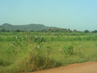
Kadugli is a fairly nice town. It seems a lot smaller than it apparently is, which is also kind of nice. In any case, after being in Khartoum for three weeks, Kadugli was a sight for sore eyes. It was green!! There were trees! And mountains! And no sand!! Actually, it was a great time to be in Kaguli. It was the end of the rainy season, so it wasn't too muddy, and everything was quite green and smelled fresh.

In addition to Kadugli, while in South Kordofan, my colleagues and I drove to Dilling, a town to the north of Kadugli, to visit a legal aid center UNDP supports there. The drive was quite beautiful, although extremely bumpy!. And I saw a very large monkey crossing the road, which was pretty exciting (this was before I knew that we have a monkey who lives in the trees outside our UNDP office here in Khartoum).

From South Kordofan, I flew by helicopter to Abyei. I was SO excited about the helicopter ride. I'd never been in a helicopter before! But now I really want to travel in one of those small helicopters with large windows that are used for flight-seeing. This was a large (18 passenger) military transport helicopter, with only porthole windows. Fortunately, I didn't know at the time of this trip that the helicopters the UN uses have really poor safety records. On the other hand, I have also heard since that trip that helicopter crashes are rarely fatal, which is good the know. :-)

Here's a really dreadful picture of me in the helicopter.

Kadugli seemed like a fairly small town when I was there, but it is a major city compared to Abyei. While Kadugli has 100,000 people compared to Abyei's 20,000, the bigger difference is in the level of development. While Kadugli has electricity, mobile phone service, a number of pubic institutions, and a fairly substantial downtown comprised a permanent brick and concrete structures, Abyei is very much a village. It is made up primarily of tukuls (round mud huts with grass roofs). Moreover, the market is comprised primarily of business constructed from tree branches, plastic sheeting, and occassionally corrugated metal. For those who are familiar with Eritrea (if only from this blog), Kadugli is probably comparable to Barentu or Tesseney whereas Abyei is like Guluj. In fact, we even ate a few times at this restaurant across from the UNMIS compound that reminded me of the restaurant we ate at in Guluj when I was there in October 2006 (There are photos of that restaurant on this blog. It's the one constructed from tree branches, straw mats, and UNHCR sheeting.)
This said, I actually preferred Abyei. I can't really explain what it was. It was just a feeling I got. But in any case, I enjoyed my time there. For one thing, you can buy beer in the market in Abyei, which is special when you're living in dry Khartoum. Another factor might be the fact that there are a bizarre number of Americans working for the UN and NGOs in Abyei. In fact, this one American guy I met there said that if you were just to look at Abyei, you would get the impression that Americans dominate international humanitarian work, which of course is simply untrue. Actually, for a western country, the US is significantly under-represented.
Abyei is fairly far south in Sudan, and although technically part of Northern Sudan, it's much more like the south of the country than it is like the north. So, I enjoyed that aspect of it as well.
While in Abyei, we (some of my Abyei-based UNDP colleagues and I) drove south to the village of Agok, a SPLM-controlled village in the administrative area of Abyei. On the way there, we passed a waterway, which apparently is home to a large hippo. I really like hippos, and was really hoping to see it. Unfortunately, we didn't may. But now I really feel a need to go back there to see it!!. We also saw some boys fishing while standing in flood waters up to their waists. These seemed like a nice scene until the local Dinka man who was in the car with us said that the boys should be careful because the flood waters were full of crocodiles.
Agok was a sad scene. If you remember, in September of this year, much of Africa flooded, and southern Sudan was badly hit. Agok was one of the victims of this flooding. When we got there, we saw a number of submerged tukuls. The market in the center of town was also half under water, with the streets looking more like rivers or streams. I'm not sure how many residents lost there homes, but I got the impression that it must have been a large percentage. It was very sad. And it was unfortunate, because Agok actually looked like a pretty nice place to live. It was quite green and lush, with far more trees than the town of Abyei.
In any case, after five days in the field, I headed back to Khartoum. But getting back proved to be more of an adventure than I thought. First, my helicopter from Abyei to Kadugli was delayed by 2 hours. Then, we got to Kadugli and had to wait for a plane to Khartoum. When the plane arrived (the Canadian one) and we boarded, we were told that rather than flying directly to Khartoum, we were going to be going via El Obeid. However, we all thought this meant that we would stop in El Obeid and just pick up more passengers. But when we got to El Obeid, we were all instructed to get off the plane. The flight attendant told us that the plane we had been on was picking up Chinese soldiers working for UNMIS and going to Wau (in South Sudan). So, we had to get off and sit for about 2 hours in the airport in El Obeid before our plane showed up. This plane was a large Spanish aircraft, the largest plane in the UNMIS fleet.
Finally the plane arrived, and we all boarded. And it headed off the runway. The plane reved up, and we set off down the runway. But before we left the tarmak, the plane ground to halt. We were told there was a problem, and we had to go back. We then taxied back to the airport and sat there in the plane while they apparently solved the problem. Then we tried again. And the whole cycle repeated itself. Finally, on the third try and after about an hour and half in the plane, we finally took off. And after about 9 hours of travel time (Abyei is about 3 hours from Khartoum by air), I made it safely back home.
Labels: Sudan


 The Confluence of the Nile


